Selected Projects
In Between the Boundaries
Winner of Second Prize of the competition “Ideas for Prishtina”
Reimagine Prishtina’s urban landscape with a transformative thesis on diffused metropolitan centrality. From revitalizing the train station to fostering a network of interconnected facilities, parks, and cultural nodes, this design envisions a sustainable, nature-integrated urban environment. Enhancing quality of life, preserving cultural heritage, and promoting resilience, this comprehensive proposal invites residents to experience a vibrant and environmentally conscious city.
In Between the Boundaries
Nature holds profound significance for the residents of Kosovo, as it is intricately woven into their intangible heritage. The lifestyle of this shepherd, exemplifies the close relationship between people and their environment. The need to send his sheep to graze in the abundant lands shaped his way of life, forcing to adapt to the natural surroundings. This connection is beautifully symbolized by the traditional Albanian clothing, particularly the Plisi hat, adorned with a long white scarf that stretched up to three meters. From the early age of 16 until their final breath, men would wear this scarf, a testament to their arduous journeys across vast distances and treacherous mountains, where danger lurked at every turn. In a poignant tradition, the scarf would serve as a final covering, honoring the shepherd’s life if they met an untimely end on the rugged peaks, where retrieval was impossible. This representation underscores the intimate relationship between Kosovo residents and nature, shaping their customs, way of life, and artistic expressions, while serving as a timeless connection to their homeland.

Kosovo’s strategic position as a crucial junction between central Europe and the Adriatic Sea has led to the gradual loss of its close relationship with the environment. As infrastructure developed, the once inseparable harmony with nature started to fade, leaving behind traces of a diminishing bond. In our rapidly urbanizing world, where cities are expanding at an unprecedented rate, it has become more essential than ever to prioritize nature and integrate it into urban design. We are witnessing the rise of concrete jungles that are gradually disconnecting urban dwellers from the natural world. This disconnection not only affects our physical and mental health but also poses long-term sustainability challenges for our cities. As green spaces dwindle, natural elements fade away, and the sense of place diminishes, we are left with profound implications for the quality of life of city residents.


This project delves into the complex problem of the disconnection between the city of Prishtina and its natural opportunities. By unraveling the root causes and consequences of this issue, design strategies are proposed to bridge the gap and foster a stronger relationship between the city and its natural surroundings. The concept of diffused centralities plays a pivotal role in this transformation, allowing us to reimagine urban spaces as thriving ecosystems that embrace nature and prioritize the well-being of their inhabitants.
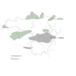
Development Indicators
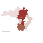
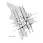
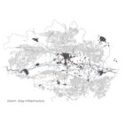
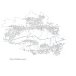
Kosovo’s distinct geography, defined by imposing mountain peaks and traversed by rivers connecting to the seas, holds a rich historical and geopolitical significance. These rivers, like Drini i Bardhe and Iber, not only shape the land but also served as historical passages, reflecting the region’s interconnected past. The evolution of these passages, influenced by political changes, has impacted Kosovo’s development. Post-independence, with Pristina as the capital, the focus of development has shifted southward. The intricate interplay of geography and geopolitics is a key aspect of Kosovo’s dynamic evolution, as seen in the most challenging yet rapidly developing region, reflecting Pedro B. Ortiz’s principles in ‘The Art of Shaping Metropolis.

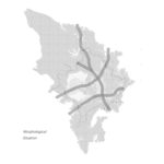
Morphological Situation
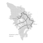
Development Political Influences
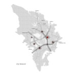
City Network

Network
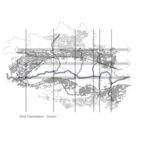
Grid Formation
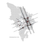
Developing Focus Area
Base Elements
The process unfolds through the examination of three fundamental elements: green infrastructure, gray infrastructure, and the fusion of both, known as Green-gray infrastructure. By meticulously analyzing each element independently, we discern their distinct characteristics, allowing us to define our tools. This deliberate approach unveils the essence of the project at its core.

Green Infrastructure
Gray Infrastructure
Green-Gray Infrastructure
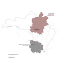
Regional Analysis

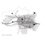
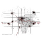
Centered on the Municipality of Prishtina, along with constituent municipalities, the region features a strategic capital, well-connected by EU routes, regional roads, and a railway system.
The interplay of green and gray infrastructure shapes city limits, allowing urban expansion. This cohesive network, aligned with land morphology, connects cities. Key Green-gray systems highlight the main development area, signifying the focal zone.

Green Infrastructure
Grid formation
Gray Infrastructure
Metro-Matrix
Green-Gray Infrastructure
Defining Focus Area
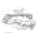
Municipal Analysis

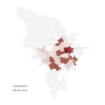
Emerging the natural elements of the municipality; Green System, we may identify the green system as a whole, while it identifies the morphological state of the area, and defines important focus zones. Following the metro-matrix system
defined from the railways, new road is developed, which supports the morphology and frees the centralization. By merging the Green and Gray Infrastructure together, the system can be identified, and the highlighted zones clarify the important focus areas.

Green Infrastructure
Grid formation
Gray Infrastructure
Metro-Matrix
Green-Gray Infrastructure
Conceptual Mediators
City Analysis
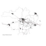
Prishtina’s unique morphological setting, surrounded by mountains, provides panoramic views and diverse natural assets. The city’s development, impacted by historical decisions, covered valuable rivers in the mid-20th century, altering its geography.
The morphological movements of the terrain, termed the Green System, shape the urban fabric. Structured urban layouts follow the slightly flat terrain, transitioning as they reach the mountains. Connectivity, particularly railways, is sensitive to morphology, influencing urban design.
Understanding these elements, the metro-matrix forms centrality and organic strength lines, shaping the urban satellite grid. The interaction of Green and Gray Infrastructure reveals development pathways. Identified areas, like the northern peripherial zone with high hills, the central zone with a nodal centrality, and the fluid southern wedge, represent strategic development areas. These strategic zones integrate morphology, natural elements, and the metro-matrix, guiding the city’s growth.

Green Infrastructure
Natural Elements
Gray Infrastructure
Metro-Matrix
Green-Gray Infrastructure
Synergy

Green Infrastructure
Matrix Formation
Gray Infrastructure
Symbolic Mediators
Green-Gray Infrastructure
Strategical Areas
Strategical development

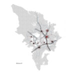
Defining each wedge’s potential, the chosen strategic area holds significant influence, propelling Prishtina towards metropolitan status while preserving its connection with nature. Wedge Two, crossing the centrality, aims to link with nature, creating a new network for improved mobility. With two hills creating a unique pit, this area encompasses rich natural elements, including forestry, rivers, meadows, and urban greenery. It becomes a nexus for urban spaces, tourist zones, and a path to forestry, integrating environmental considerations. Towards the northeast, a new metro connection eases traffic, emphasizing peripherial treatment and park entrances. In the southwest, the strategy connects urban sites to agriculture, promoting production and addressing environmental concerns from nearby power plants. This strategy, diverse yet convergent in approach, promises panoramic views, enticing exploration and engagement.


The strategy encompasses the development of a robust mobility system that extends to the existing
train station, effectively connecting regional mobility from the directional centrality and guiding it towards the city entrance. This entrance serves as a vital continuation of the system, resembling a spine that functions as a feeding route within the identified nodes. By defining and establishing the centrality, we can pinpoint the starting point of our intervention: the old train station. This strategic choice enables us to facilitate a gradual diffusion throughout the city, ultimately leading to the summit of the hills. This connection serves as a gateway to embracing nature, including Germia Park, and integrates agricultural lands into the urban fabric.

Local – Strategy
Vertical Connectivity
Connection Field

Urban Fabric
Horizontal Connectivity
Feeding Nodes

Network
Symbolic Mediators
Feeding Route Diagram


With a clear understanding of the elements comprising the diffused centrality of the site, our attention turns to the development of two vital aspects: green infrastructure and gray infrastructure. These two systems work in harmony to shape the overall fabric of our design. We begin by examining the existing green infrastructure present within the site. This analysis allows us to identify key elements that contribute to the natural environment and serve as the foundation for our design interventions. From this understanding, we define our green conceptual mediators, which act as guiding principles in establishing the axis of connection and integration within the site.

Green & Blue Elements
Conceptual Mediators
Conceptual Green Mediators
Defining Porozity

Conceptual Mediators
Development Elements
Connecting Axes
Interconnection
Strategy
This integration of natural and built elements establishes a strong foundation for the development, fostering a sustainable and resilient environment. Through the careful consideration of green and gray infrastructure, we envision a site that not only offers functional connectivity but also prioritizes the well-being of its inhabitants and the surrounding ecosystem. The resulting design embraces the principles of sustainability, promoting a balance between human needs and the natural environment.


In the realm of design, the concept of “Total Visible Landscape” captivates our imagination and beckons us to embark on a journey of exploration and discovery. It encompasses the idea of experiencing a landscape in its entirety, capturing every facet that unfolds before our eyes. With a discerning gaze, we immerse ourselves in the interplay of colors, textures, and forms that shape the landscape. The towering trees, meandering river, and majestic hills all play their part in crafting a symphony of visual harmony. Beyond the aesthetics, the Total Visible Landscape delves deeper, unearthing the stories and narratives woven within the terrain. It invites us to appreciate the historical, cultural, and ecological layers that enrich the place, evoking a sense of connection and belonging.
Node
Embark on a journey to rejuvenate Tortolì’s historic charm with a transformative project centered on Battery Park in Arbatax. This initiative seeks to breathe new life into a WWII military installation, perched atop a hill with breathtaking views of the iconic Red Rocks Gulf. Through a thoughtful narrative woven into the city fabric, our project aims to integrate the site seamlessly into the city’s identity, inviting residents and visitors to experience the rich history, captivating landscapes, and vibrant traditions of this enchanting Sardinian town.
Node
Node stands as a beacon of visionary design, radiating beyond its geographical confines to ignite a ripple effect of development across a vast expanse. It aspires to serve as a transformative force, not only in its immediate surroundings but also as a catalyst for progress and innovation on a regional scale. By creating a dynamic platform, Node invites a diverse array of stakeholders to engage actively in shaping the future of the landscape, fostering collaboration and synergy among disparate voices and perspectives.

Urban Fabric
Blocks
Parameters

Network
Network Directionalities
Form

Connection
Grid System
Field of Action
strategy
Rooted in a deep understanding of the town’s context, Node seeks to curate an immersive experience, guiding visitors through various moments that collectively portray the site as a cohesive entity with multiple interconnected elements.

Extensive analysis informs strategic interventions, pinpointing areas in need of enhancement to realize the envisioned experience fully. The overarching strategy is to establish a symbiotic connection on both sides of the main road, extending from the city’s core, and culminating at the node—a pivotal convergence point for nature, infrastructure, mountains, urban fabric, and the sea.


Node
Central to the project’s narrative is the intrinsic value of the land, characterized by its distinctive red rocks and Battery Park, visible upon entering the city but inaccessible. The narrative unfolds as visitors embark on a journey, gradually unveiling different facets of the site until they reach the final destination—a vantage point where all elements harmonize, offering a panoramic view of the entire landscape. Here, diverse activities converge, fostering economic growth and fostering a sense of belonging among locals.


Strategical Evolution


At the heart of Node lies the critical node, concealed yet intrinsically linked to nature, acting as a conduit between humanity and the environment. The design endeavor aims to bridge this gap, facilitating access to nature while preserving its integrity.
Elements


Masterplan
The masterplan unfolds organically from the entrance point—the train station—where pathways delineate the journey, each moment fostering a connection to the site’s essence. The pathway to the node embodies tranquility, culminating in a profound connection that reveals the site’s full potential. Only then can visitors truly embrace all that the site has to offer.

Larkshead
Discover ‘Larkshead,’ a visionary urban intervention centered on redefining Milan’s Northern landscape. This project intricately weaves together natural and urban elements, focusing on key points such as green connectivity, water systems, and the convergence of natural and urban landscapes. Embracing ecological considerations, the project integrates Natural-Based Solutions (NBS) and introduces a green wedge, connecting seamlessly to the peripheral landscape.
Larkshead
Nestled within the lush green wedges of Milan, Italy, our project emerges as a beacon of transformation within the Northern Wedge. Through rigorous analysis and strategic foresight, a visionary initiative is unveiled to reshape the urban fabric and redefine the narrative of this city’s future.

Blocks
Networks
Form
Water

Green Infrastructure
Urban Tissue
Axis
Socio-Cultural Aspect
strategy
Informed by exhaustive analysis, the strategic blueprint unfolds along four distinct axes, tracing a path from the historic city center to the outer reaches of our urban landscape. Each axis serves as a gateway to new possibilities, offering insights that inform the intervention and drive the evolution of the built environment.


Harnessing the regenerative power of Nature-Based Solutions (NBS), this project embraces a holistic approach to sustainability and resilience. From water management to biodiversity conservation, the interventions seek to harmonize human activity with the natural world, fostering equilibrium and fostering a symbiotic relationship between urban life and the environment.

Node
At the nexus of the intervention lies a critical node, where the convergence of key thoroughfares intersects with the natural contours of Parco Nord. Here, amidst the interplay of urban infrastructure and ecological systems, the design ethos comes to life, bridging divides and forging connections that enrich the fabric of our urban landscape.

Noise Pollution
Flooding Risk
Heat Island

Area of Intervention
Green Fragmentation
Functions inside edges
Conceptual Development
Rooted in a deep understanding of site dynamics, the conceptual framework unfolds as a narrative of discovery and innovation. From the subtle undulations of the terrain to the intricate interplay of light and shadow, each element is meticulously crafted to evoke a sense of place and purpose, inviting exploration and engagement.

Masterplan
The masterplan emerges as a testament to thoughtful stewardship and mindful design. Seamlessly integrating elements of accessibility, sustainability, and aesthetic appeal, vision unfolds as a cohesive tapestry of form and function, enriching the urban experience and enhancing the quality of life for all who inhabit this city.


Elements
Central to the design narrative are the elemental forces that shape the intervention, from verdant green spaces to dynamic pedestrian thoroughfares. As we embark on this transformative journey, we invite our community to join us in reimagining the possibilities of our urban landscape and embracing a future defined by resilience, vibrancy, and connection.

Lava Flow
Experience the synergy of nature and architecture in ‘Lava Flow,’ where the new house emerges at the head of the lava element, serving as a captivating visual point directed toward the sea. This harmonious integration encapsulates the essence of La Palma’s beauty in a seamless and awe-inspiring architectural marvel.
This conceptual project done in a Workshop, is also featured in Prof. Juan Manuel Palerm Salazar’s publication;
‘Como Proyectar Habitar Construir en La Palma
Lava Flow
Nestled amidst the rugged splendor of Spain’s Canary Islands, La Palma beckons with its untamed beauty and volcanic majesty. From the towering peaks of Teneguía to the cobblestone streets of Santa Cruz de la Palma, each facet of this island exudes a raw, elemental allure. Caldera de Taburiente National Park, with its verdant forests and cascading waterfalls, serves as a testament to the island’s rich natural heritage. Through the lens of Hillshade, the island’s topography comes alive, revealing a tapestry of hills, volcanoes, and coastal vistas that define its unique character.


Strategical Development
As we delve deeper into the island’s formation, a nuanced understanding emerges, tracing the evolution of its landscape from core to coast. The interconnectedness of its elements unfolds, with hills and volcanoes forming a cohesive system that shapes the island’s identity. From ancient lava flows to the emergence of new landforms, each geological feature tells a story of transformation and adaptation.


Masterplan
Guided by this narrative, the masterplan takes shape, leveraging the island’s natural contours to form the strategical approach. Two key elements serve as focal points for development, with a keen focus on connectivity and integration. The head of the lava flow emerges as a visual and strategic nexus, drawing inspiration from the island’s dynamic terrain.


Architectural Integration
The architectural intervention embraces the spirit of the land, weaving seamlessly into the fabric of La Palma’s volcanic landscape. Drawing from the elemental forces of lava and sea, our structure emerges as a harmonious union of form and function. From its organic curves to its tactile textures, every detail reflects a reverence for nature’s sublime beauty.

As the residents traverse this house, they embark on a journey of discovery and connection, guided by the rhythm of the land. From panoramic vistas of the horizon to intimate encounters with the natural world, each moment invites contemplation and engagement.
It is here, amidst the convergence of earth and sky, that the true essence of La Palma is revealed—a testament to the enduring bond between humanity and the natural world.

Coultura
Experience ‘Coltura: Culture & the Productive Landscape,’ a transformative project reimagining Cremona’s urban-nature relationship. Focused on revitalizing the Po Valley, it creatively addresses ecological challenges through sensory-rich interventions. The showcased part of the project focuses mainly in using tools to conduct analysis done in this project.
Coltura – Culture & The Productive Landscape
The Coultura project, centered in Cremona within the Po Valley, aims to address the diminishing protected areas and agricultural practices negatively impacting the environment. By revitalizing the agricultural landscape, the project seeks to restore biodiversity, improve air quality, and enhance the overall ecological balance of the region.

The Po River, winding through the region, plays a pivotal role in the project’s strategic development. Its banks, intertwined with the agricultural landscape, serve as focal points for ecological restoration and cultural rejuvenation initiatives. The river’s historical significance and ecological value underscore its importance in shaping the project’s objectives.

Mapping
Utilizing data extracted from sensoring imagery, the mapping effort for the Coultura project offers a comprehensive understanding of the region’s landscape dynamics. These maps provide crucial insights into the evolution of land use patterns, vegetation cover, and hydrological features over time. By analyzing historical trends and current conditions, the project team gains valuable information to guide strategic decision-making for the implementation of interventions aimed at revitalizing the agricultural landscape. The mapping process revealed significant shifts in land use patterns and ecological dynamics within the Cremona region. By identifying areas of agricultural intensification, urban expansion, and environmental degradation, the project team gained a deeper understanding of the challenges facing the landscape.


Armed with this knowledge, strategic interventions were developed to enhance biodiversity, mitigate environmental degradation, and promote sustainable land management practices.
Masterplan
The masterplan integrates various interventions to create a cohesive vision for the region. By linking urban and rural spaces via a network of paths and common elements, the plan fosters a seamless transition between the city and the countryside. Casinas, historical buildings scattered throughout the landscape, are repurposed as cultural hubs, further enriching the local experience.

Close Up I
Focused on the agricultural land and forest bordering the Po River, this close-up highlights strategic interventions aimed at maximizing productivity and preserving natural habitats. Canals and tree plantings enhance water management and biodiversity, while cascinas serve as cultural landmarks, celebrating the region’s agricultural heritage.


Close Up II
This close-up zooms in on an existing restaurant situated along a canal, showcasing how interventions enhance both functionality and aesthetics. The re-opened canals and landscape features create a sensory-rich environment, inviting visitors to pause and appreciate the natural beauty of the surroundings.


Close Up III
Addressing the challenges posed by infrastructure barriers and flooding areas, this close-up emphasizes the adaptive reuse of abandoned farmhouses and the creation of cultural nodes. By repurposing these structures and integrating them into the landscape, the project aims to attract tourists and locals alike, fostering a deeper connection to the region’s cultural and natural heritage.


Coultura project represents a holistic approach to landscape revitalization, blending ecological restoration with cultural preservation. Through strategic interventions and community engagement, the project aims to create a dynamic and sustainable landscape that celebrates the region’s rich cultural and natural heritage.
My Booklets
In Between the Boundaries
Please wait while flipbook is loading. For more related info, FAQs and issues please refer to DearFlip WordPress Flipbook Plugin Help documentation.
Ready to Get Started?
Don’t wait!
Connect with me today to discuss your project. I’m here to help turn your dreams into reality.